Notes on Surveillance as a Planning Issue
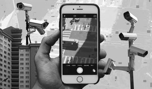
Whether you’re sitting in a public square, swiping your card to buy metro fare, or downloading an app for parking, chances are your data is being collected by someone. This surveillance—video footage of you, your location, your address—is embedded in public and semi-public spaces, and the apps that accompany them.
This reality presents pressing concerns for data privacy and racial justice in contemporary cities as they create risks for racialized groups, undocumented immigrants, unhoused people, and others who are disproportionately profiled and targeted by law enforcement. Even so, urban planning, urban design, and allied fields have not yet established a repertoire of resistance to the increasingly common use of such surveillance in the environments they create.
The ways that public entities and their private partners harvest data in public spaces and how this information is used remains opaque. We don’t know what is being collected exactly, or where. We don't fully know the legal bounds of how this information can be used. And we definitely don’t know the potential social consequences that this type of surveillance may yet wield. Yet, a growing ‘smart cities’ discourse promises to forge public-private partnerships between developers and with corporations (like Verizon,Comcastand Motorola) to make cities safer and more efficient through surveillance cameras, sensors, gunshot and traffic detection technology, and the collection of user data . Such corporations may contract with municipal governments to harvest data and have forged a lucrative industry from the selling of personal data–currently estimated at 77 billion USD, and expected to increase to 103 billion USD by 2027. At the same time, other surveillance strategies, like, New York’s Safe Shopper program and Detroit’s Project Green Light experiment with agreements with local businesses to provide live feeds of surveillance cameras to law enforcement. The surveillance apparatus of public agencies expands beyond local law enforcement and is an integral part of the operations of the Department of Homeland Security, that also houses agencies involved in public surveillance activities like Immigration and Customs Enforcement (ICE). At the state level, the Office of Emergency Management of New York shares a division with Homeland Security, linking climate threats and terror threats through their mission and their surveillance activities.
At the same time, individuals and small businesses are called on to help contribute to this surveillance apparatus. A suite of mass marketed surveillance technologies are now available, including doorbell cameras (like Ring and Nest) and neighborhood based apps (like NextDoor and Citizen) that allow for neighbors to surveille their communities, working as surrogates for law enforcement. Each of these surveillance strategies presents the risk of breaches of privacy, poses the risk of wrongful conviction through the use of imprecise technology, and generate unnecessary confrontations with law enforcement for over-policed populations.
Many planners, while often progressive, tend to act as bystanders in the debates on surveillance and data privacy. While they may make public statements in support of divestment from policing and surveillance practices, this show of moral support is unsatisfactory in addressing urban planning’s role as a key area of intervention towards resisting unjust surveillance practices.
Since surveillance is a feature of nearly every aspect of planning—from collecting user data from transit riders to surveilling public housing residents to CCTV networks in privately owned public spaces—why aren’t the risks of these technologies in the built environment more of a concern for planners? And how can we better understand the roles that planners can take in fighting for urban spaces that are more inclusive and democratic in their treatment of groups vulnerable to privacy breaches, harassment, and wrongful imprisonment at the hands of such technologies?
These questions are the focal point of a project I am beginning that is a partnership between the Pratt Center for Community Development, the Surveillance Technology Oversight Project (STOP), and Dalhousie University. In the coming months, I will investigate the types of technologies that surveille us and speak with planners along the way to imagine an alternative set of practices. As this investigation unfolds, I’ll report on the insights gained from the conversations I’ve had with planners to better understand the ways their practices interact with complex and controversial issues of surveillance in public spaces.