Evaluating Urban Manufacturing Vulnerability to Sea Level Rise
The United States’ industrial, transportation, and logistics sectors are facing an almost existential threat from climate change: rising seas. In urban areas, industrial land uses have historically been situated near waterfronts for access to shipping and rail, making them particularly vulnerable to flooding from intensifying tidal patterns, coastal storm surges, and stormwater flooding. These coastal areas support critical infrastructure, including warehousing, construction services, manufacturing, solid and liquid waste facilities, airports, railyards, and electrical substations. They also provide high-quality, well-paying career opportunities with lower barriers to entry, which is an important facet of economic justice in cities.
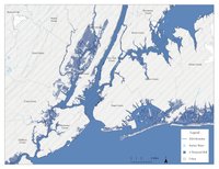
In New York City, based on the U.S. National Oceanic and Atmospheric Administration's projection of a six-foot sea-level rise by 2100 and the City of New York’s zoning, tax lot, and building footprint data, we estimate that:
- Nearly one-fourth (23 percent) of the city’s 126 square kilometers of industrially zoned land will be underwater.
- Over 2,300 (7 percent) of the city’s 32,400 industrial buildings will be impacted, representing approximately 49 million square feet of industrial building area.
- The assessed value (typically a fraction of real value) of those at-risk properties is approximately $3.5 billion.
Despite these alarming figures, this issue has received limited research and policy attention. One reason for this is a data gap: data on most of the metropolitan landscape is fragmented across a patchwork of state, county, and municipal governments. In the New York City region, we estimate that a six-foot rise in sea levels could impact nearly 100 municipalities across three states.
Our team, consisting of Mark Heller (Assistant Professor, Graduate Architecture, Landscape Architecture, and Urban Design), John Lauermann (Associate Professor, School of Information), and John Shapiro (Professor, Graduate Center for Planning and the Environment), plans to build an interactive, accessible database of urban industrial land and infrastructure, overlapping with vulnerability data on floodplains and sea level rise projections. We will work alongside two community partners: the Urban Manufacturing Alliance (UMA) and the Resilience, Education, Training, and Innovation (RETI) Center.